Work Management
Advanced Work Management enables organizations to allocate and track work efficiently, and to do so in accordance with agreed processes and procedures. MX provides extensive, flexible facilities for work management that allows users to deploy resources on different job types over wide geographic areas and yet monitor the progress and remain in control.
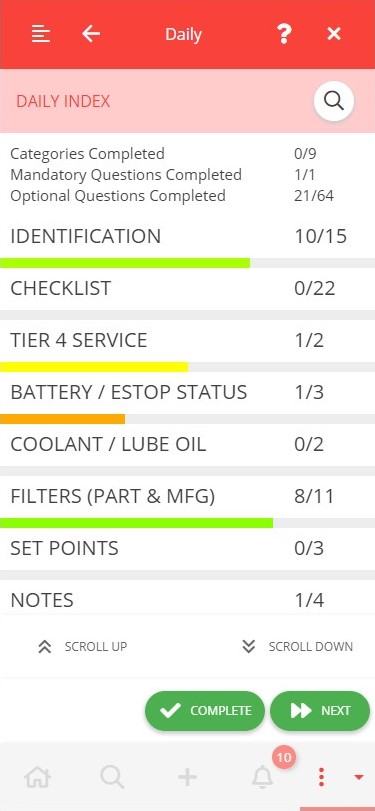
Powerful work process mapping and job templates allow for the rapid configuration and deployment of new work streams. Authorized users can change the field inspection forms in-flight and thereby require field crews to capture additional information as required.
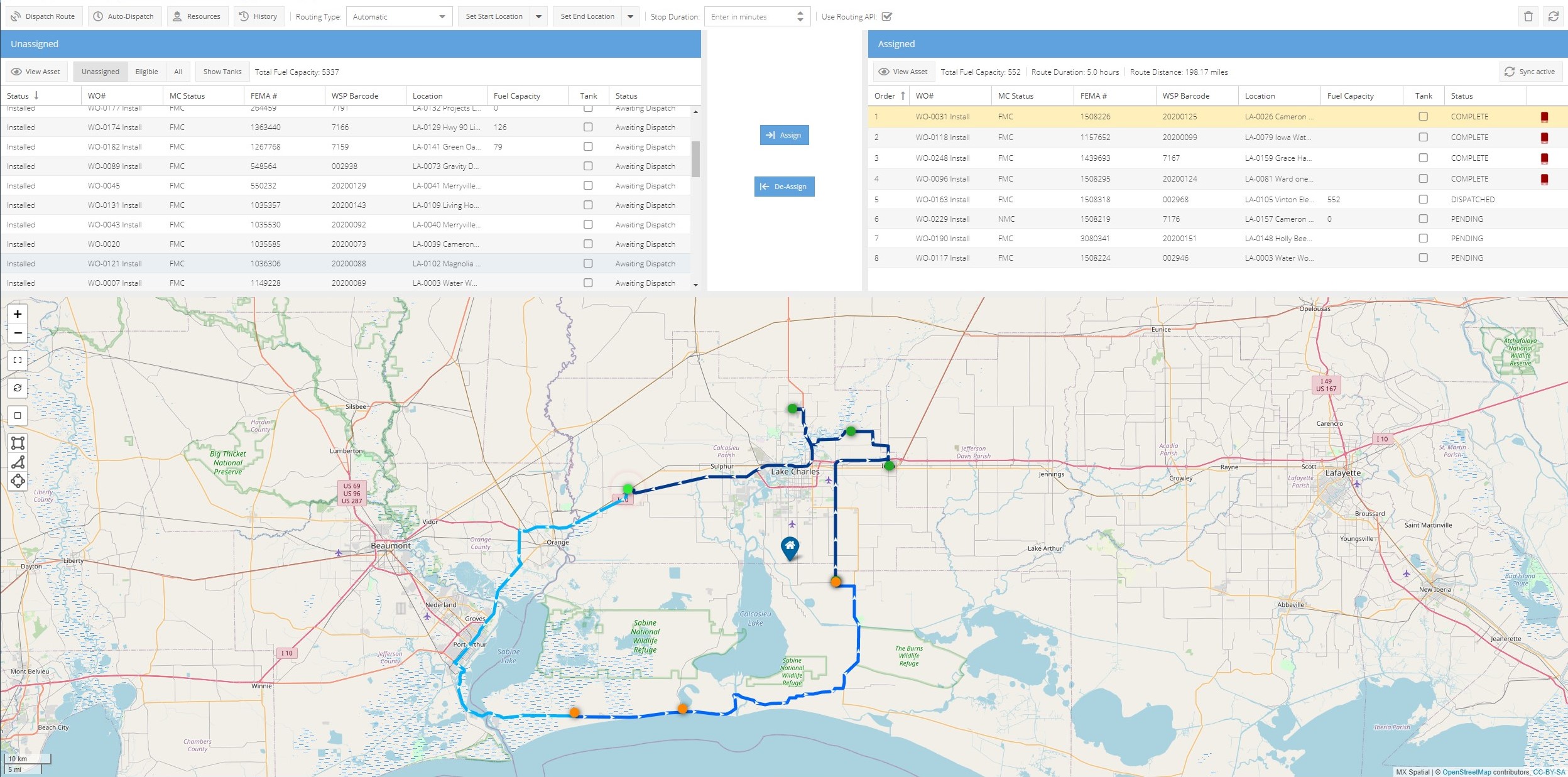
A sophisticated resource allocation and dispatching engine combines automated allocation and dispatching according to demands of the job with manual dispatching by operations management staff.
MX provides for various auto-routing of field crews including flexible manual creation of routes with automated road or coordinate based routing.
By using the MX app field crews can continue to use the full functionality of the field work management system as they move in and out of connectivity. This has proven to be highly valuable in disaster response where there has been unreliable or complete loss of internet/network service.
The work management system provides full archiving of key activities and operations. It also gives the various management groups access to performance reports and dashboards that enable them to effectively view and manage performance.
Asset Management
MX provides a fully integrated geo-spatial asset management solution. Asset models can be defined within MX or integrated from other systems. Our asset model enables attributes, maintenance requirements, etc to be applied to new assets immediately, automating the specification of planned maintenance requirements.
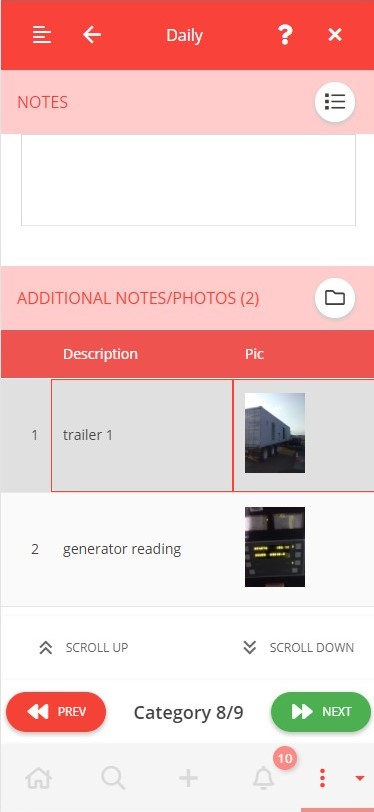
Asset inspection can enforce the capture of standard data and also include condition specific requirements based upon answers to earlier questions. Pictures and videos can be attached to the inspection records and shared with others as required.
All relevant records such as personnel, time, location and content of asset management activities are recorded and available in dashboards, reports and the archive.
Fully integrated with our geo-spatial solution, all assets and relevant management activities can be viewed on our map.
Workforce Management
Effective management of field resources is vital in operations management. MX provides a powerful workforce management solution that allows users to get up and running quickly and to track and manage field personnel. This includes a flexible ‘Contractor Portal’ that enables sub-contractors to enter data on personnel taking part in the work as their teams arrive on the job.
MX provides for all relevant personnel records and can quickly capture data including scanning driver licenses, allocating bar codes, printing authorized badges.
Our workforce management functionality includes key supporting features such as:
- Accreditations, training records, skills, etc
- Accountability management
- Personnel scanning
- Extensive financial records management and invoice / billing support.
Fully integrated with work and geo-spatial management, our workforce solution has enabled our customers to manage long term work and maintenance activities, and to respond quickly to emergency with many 100s of staff.
Operations Management & Coordination
Our customers typically operate in complex environments that involve a range of different activities and several agencies or departments. This is the norm in for example hurricane response and restoration or in city construction coordination. MX is used in these situations to provide a ‘Meta-level’ of operations management and deliver multi-agency coordination and process management.
In this environment MX is integrated with department or agency systems that carry out local operations. By tracking and managing their progress on local activities MX can coordinate the bigger picture response or work process.
This multi-agency coordination has been central to successful deployments in areas such as the multi-agency coordination of utility and city construction work that has delivered $millions in costs savings.
Emergency Response
MX provides comprehensive support to customers in Emergency Response for Federal and State emergencies. It enables them to quickly and effectively assemble a wide range of personnel and assets, and to fully establish the Mission at the Incident Support Base in a very short space of time.
Personnel and asset data can be imported from suppliers or created in MX. Relevant data such as bar codes, badges, personnel details, etc is all managed inside MX supporting quick and accurate daily scan ins for personnel or field inspections of assets.
MX can automatically import mission work instructions from the lead agency and immediately get work underway in accordance with contracted service response requirements.
Operations personnel are provided with an effective, real time information on the response to the mission. MX workflows help ensure that this is all done in accordance with agreed procedures.
Field crews are dispatched and routed with their maintenance tasks. User friendly screens help them do their inspection, maintenance and reporting tasks accurately with limited training.
Management staff and supporting agencies are given overviews through their dashboards and can drill down to detailed activities as required.
MX will track daily mission costs thereby helping senior staff and financial controllers to keep track of the financial aspects of the response.
The compliance and audit function helps to ensure good practice and significantly reduces the after-event costs.
Geospatial Data Management and Analytics
All areas of key areas of MX functionality are supported by MX:Spatial, our powerful geo-spatial processing and presentation platform. Our customer applications typically require control of field assets and operations, and a range of geo-spatial presentation and management features.
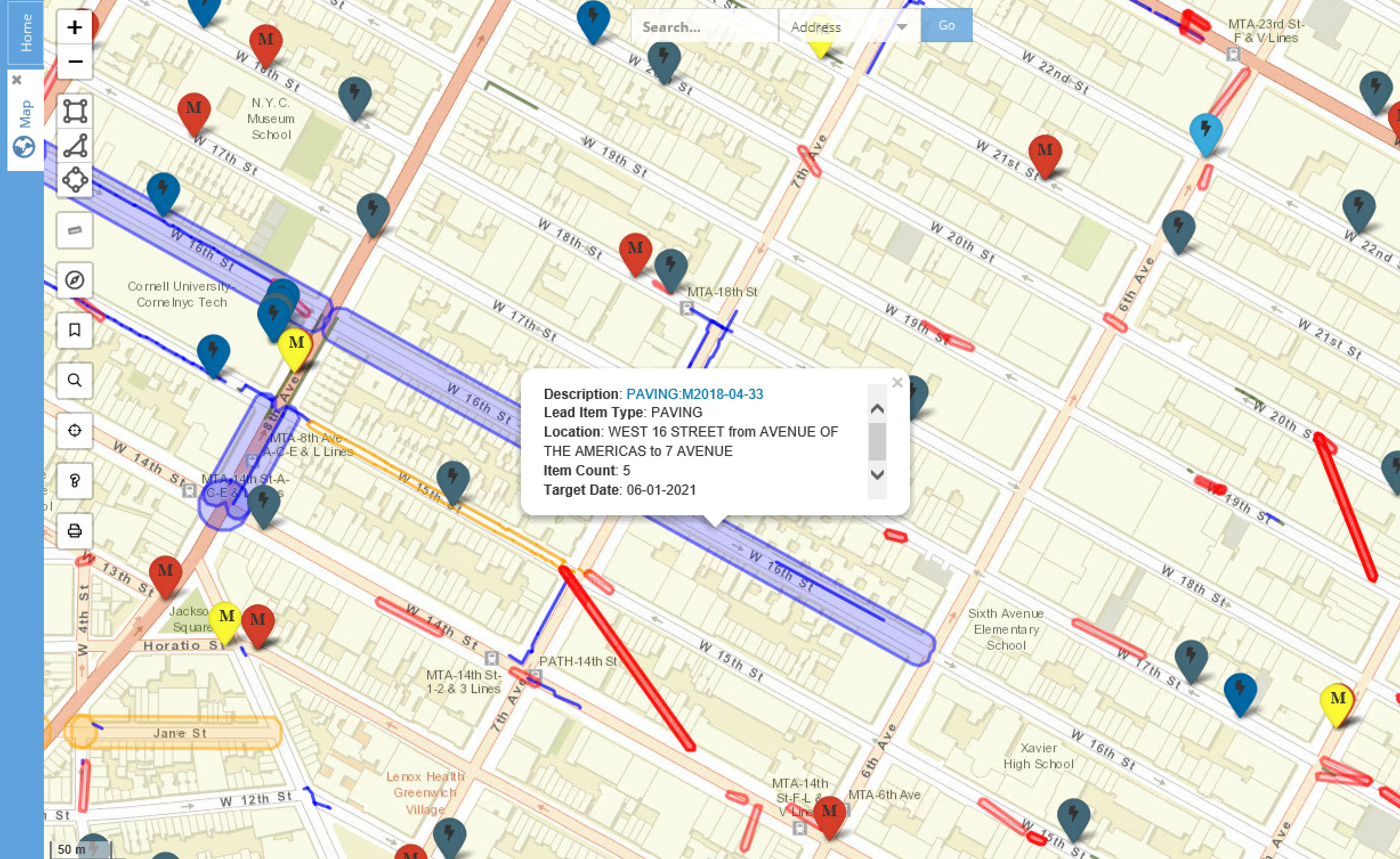
In addition to displaying internal asset and work data MX:Spatial will typically import data from other system and locate this on the MX map. This need not be explicitly spatial data. Extensive work on geo-location intelligence allows us to import low grade data and locate this accurately and meaningfully in geo-spatial terms. For example, New York City Department of Transport repaving plans are issued daily as spreadsheet and are imported and projected as street segment plans in MX – a much more useful representation that can be used in many ways by city departments and utilities.
MX provides a range of advanced spatial features that provide significant capabilities for users:
- Customizing base layers to show data of specific interest. This is done by condition-based filtering on the attributes of data e.g. jobs managed by a particular manager or tasks moved to a particular stage within the past week, etc.
- Combination of data in spatial searches. Users can select any two datasets and show the combined results e.g. all utility assets within environmentally sensitive areas.
- Archive storage of data. All relevant work data is stored in our archive. This allows users to search by space and time for historic activity. If for example a new project is planned or there is a local area emergency then users can search the area to immediately establish what has been done in the area over the selected period.
- Data sharing and security. Individual users or groups can create and share their map layers with selected others or all as required.
- Thematic displays. Current operational data on work is typically displayed as point, line or polygon data. However, MX allows users to display data over time as a thematic or heat map that effectively shows local area frequency over time.
- Base layer options and linking. Users can select from a range of base layer maps including satellite and other standards. They can also click through from the map to other applications such as Google Streetview at the specific location.
MX can easily import and use valuable public and corporate spatial layers made available for other uses. This includes data such as flood zones, political boundaries, utility assets, city infrastructure (bike lanes), etc. These data layers can rapidly improve the operational value of the application.
While not aiming to be a full-blown Geographical Information System in drawing terms, MX:Spatial does provide a variety of integrated content creation tools. This includes drawing and importing sketches, spatial data uploads from 3rd party applications and a sophisticated spreadsheet and drawing upload facility that enables users to create and manage their own project data.

Advanced Geospatial
Distribution utilities are being encouraged to provide for significantly higher volumes of DERs on the grid. To do this effectively a much more detailed and accurate geolocated network connectivity model is required than is needed to support centralized power distribution.
Network controllers require a detailed model from substation to customer meter and DER. This must be maintained daily to take account of changes in the network arising from issues such as asset replacement, planned maintenance and variations in the number and output of DERs.
Traditional GIS were never intended to provide this level of dynamic, detailed network model. Emerging (Distributed Energy Resource Management Systems) DERMS have largely failed to resolve the challenge of bringing the required data from multiple sources such as GIS, Work Management, Asset Management, AMI and DER databases.
MX Spatial provides not only a powerful geo-spatial operations management solution but an enterprise integration platform that draws data from existing ‘silos’ to build, maintain and share a uniquely accurate, true geo-located network model. This enables network managers to much more accurately assess the requirements and benefits of adding capacity from DERs to specific points on the network at specific times.
Key features include:
- Sophisticated tools and techniques for network asset data location, connectivity management and error correction
- Powerful spatial analytics and simulation tools
- Advanced dynamic network visualization of all aspects of the network
- Standardized network work data export and sharing platform
- Links to detailed data from existing systems
Together these tools help utilities meet the timescales required to provide for efficient, safe and effective integration of multiple DERs thereby reducing the capital investment in new T&D assets. They can do so by leveraging the significant investment in existing systems and processes, not by implementing a long and expensive GIS or DERMS solution.
Proven in some of the most challenging connectivity and distributed systems environments MX:Spatial is available to help utilities meet the need for improved management of DERs.